University of Maine Researchers Lead Development of Novel Forest Relative Density Maps
Maps will Guide Optimal Management and Resiliency of Forests Across the Continental United States
Orono, Maine – Multi-institutional scientists led by researchers at the University of Maine’s Center for Research on Sustainable Forests have created the first comprehensive, medium-resolution, wall-to-wall maps of forest relative density for the entire continental United States, providing critical tools for optimal management and increasing forest resilience.
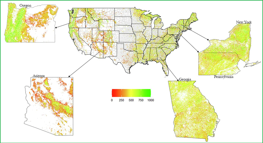
In the geospatial estimation study, published in Scientific Data, nearly 55,000 forest plots were analyzed to produce detailed 30-meter resolution maps covering approximately 2.7 billion forested pixels across the country. The research team, led by Fulbright Scholar Emmerson Chivhenge and professors Aaron Weiskittel and Adam Daigneault from UMaine’s Center for Research on Sustainable Forests, along with colleagues from the USDA Forest Service and University of Vermont, developed innovative metrics that quantify forest competition levels and productivity potential.
“These maps provide forest managers, policymakers, and scientists with unprecedented spatial detail to assess forest conditions and make informed decisions about resilient management,” said Weiskittel, a professor of forest biometrics and modeling and Director of the Center for Research on Sustainable Forests. “Understanding relative density, how crowded forests are compared to their maximum capacity, is essential for optimizing forest growth while maintaining forest health and resilience.”
The dataset reveals critical information about forest vulnerability to disturbances, including wildfires, droughts, and insect outbreaks. High-density forests face increased risk from these threats, making the new mapping tools valuable for large-scale forest planning and increasing the resiliency of US forests. A 2021 study found that US forests have become increasingly dense and may have reached a biological tipping point.
The research addresses growing interest in improving forest resilience and the need for science-based management. The maps can help identify forests with the greatest potential for additional growth while minimizing risks from density-dependent mortality that transfers biomass from living trees to dead wood forest components.
“This work demonstrates how combining traditional national forest inventory data with advanced geoinformation science and statistical methods can produce actionable information at scales relevant for both local management and national policy,” said Emmerson Chivhenge, a post-doctorate researcher now at the University of Alberta.
The publicly available datasets and maps can be accessed through the FigShare data repository, enabling forest managers, researchers and policymakers nationwide to incorporate these metrics into their planning and decision-making processes. New forest relative density maps for 2020 and 2022, providing updates and trendlines, are also now available online.
Grants from the National Science Foundation and the U.S. Department of Agriculture supported this research.
Contact:
Center for Research on Sustainable Forests
University of Maine, Orono
Email: crsf@maine.edu